95%case rate
15+ years supporting legal and regulatory proceedings
Legal Case Mapping
Evidence visualization and spatial relationships rendered as persuasive courtroom visuals.
Litigation support GIS combines technology and legal expertise — courtroom-ready maps, expert analysis, and geospatial evidence for criminal, civil, and environmental cases.
15+ years supporting legal and regulatory proceedings
Evidence visualization and spatial relationships rendered as persuasive courtroom visuals.
Credible expert testimony backed by GIS professionals with chain-of-custody documentation.
Pattern detection, evidence correlation, and deep spatial analysis that surfaces case patterns.
Data-driven negotiation and mediation support with ranked evidence and impact analysis.
Publication-quality GIS maps formatted for courtroom presentation and full metadata trails.
Litigation GIS, legal case mapping, courtroom map exhibits, and GIS expert support.
Boundary, environmental, accident, zoning, easement, route, or site context maps formatted for review.
Source citations, metadata, processing logs, assumptions, and map production notes.
We can support retained experts or produce GIS analysis and exhibits under the defined engagement.
Bring the closest real workflow. We map what you send, what your team reviews, what evidence stays visible, and what you receive at handoff.
Redacted case context, question in dispute, relevant records, geography, and deadline.
We map what can be spatially supported, document assumptions, and preserve source context.
Each exhibit includes source notes, processing steps, metadata, and limitation language.
Exhibit map, GIS package, source table, processing log, and review call.
Every exhibit should preserve source, method, and limitation context.
GIS analysis and exhibits are not legal advice.
Case records, parcels, imagery, public GIS layers, field records, and expert-provided materials.
Source citation, metadata preservation, processing log, chain-of-custody notes.
Courtroom exhibit, map packet, GIS layer, source table, and processing notes.
No vague discovery phase. You bring four or five things, we return a specific plan you can evaluate.
No open-ended retainers. No "discovery phases" that bill for months without producing anything you can evaluate.
NDA signed up front. You send the case file, relevant records, and the question in dispute. We confirm scope and return a written engagement plan.
Custom to case type — boundary, environmental, accident reconstruction, zoning, easement. Documented chain of custody at every step.
Courtroom-formatted maps with full metadata, source citations, and processing logs. Demonstrative animations available for trial.
Our GIS professionals are available for expert reports and testimony. Or we support your retained expert with mapping work they sponsor.
These open the real, interactive demos on our main site — not screenshots, not videos. Click around before you decide to talk to us.
Yes — both. We have no positional bias by case type. Conflict checks happen at intake; we decline if there's a conflict with prior work.
Large-format prints (24x36 or 36x48), digital trial presentation (TrialDirector/OnCue compatible), and animated demonstratives for jury presentation. Metadata and source citations are embedded in every exhibit.
For specific case types, yes. We have GIS professionals with deposition experience and CVs available on request. Rates and availability discussed during case review.
NDA at intake, secure document handling throughout, and full chain-of-custody documentation on every deliverable. Our work product is structured to withstand opposing-expert challenge.
Dispatch optimization, container tracking, and demand prediction built for roll-off dumpster companies — runni…
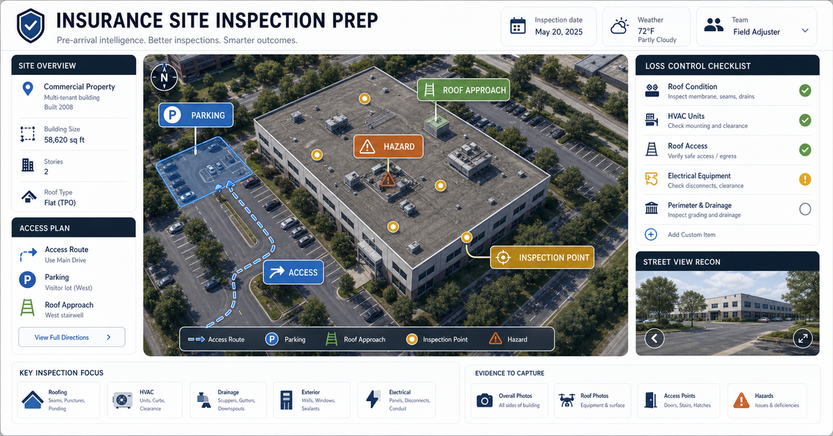
We turn inspections, asset inventories, environmental sampling, construction checks, and field surveys into mo…
Anchored in the NAIPAI pattern: ask aerial, drone, or satellite imagery useful questions, keep confidence and …
We automate spatial workflows for municipalities, utilities, and infrastructure teams — asset inventory, surve…
Confidential by default — we sign NDAs before the call. Bring the dispute, the relevant records, and we will return with what spatial evidence would strengthen your position.
Review a redacted case map